The National Hurricane Center reports around 1100 ET that Helene has reached hurricane status and is expected to produce "life-threatening storm surge, damaging winds, and flooding rains to a large portion of Florida and the southeast US. "
11AM EDT Sep 25: #Helene becomes a Hurricane. Helene is expected to bring life-threatening storm surge, damaging winds, and flooding rains to a large portion of Florida and the southeast U.S. Make sure to stay up to date with the latest forecast as we move throughout the event at… pic.twitter.com/aiDCNlravO
— National Hurricane Center (@NHC_Atlantic)
Hurricane Helene is expected to rapidly strengthen over the eastern Gulf of Mexico on Wednesday and ahead of landfall on Thursday evening along the east part of the Florida Panhandle − possibly the Big Bend area.
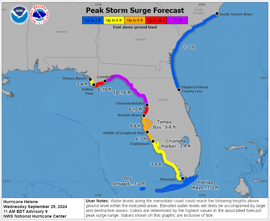
There is a danger of life-threatening storm surge from #Helene along the entire Florida Peninsula and Florida Big Bend, where a Storm Surge Warning is in effect. Residents in those areas should follow advice given by local officials and evacuate if told to do so. pic.twitter.com/WtYuQsfPD4
— National Hurricane Center (@NHC_Atlantic)
NHC forecasters believe Helene could strengthen to Category 4 status in the Gulf's warm waters.
NEW: The National Hurricane Center is now projecting at least a high-end Category 3, but is considering upgrading their forecast to reflect a Category 4 landfall. #Helene pic.twitter.com/hEhYL1WGsJ
— Matthew Cappucci (@MatthewCappucci)
This would mean the storm would achieve devastating maximum sustained winds between 130 and 156 mph
Such a massive storm pic.twitter.com/GhUwalBegW
— Hurricane Chaser Chase (@hurricane_chase)
Some areas along the Big Bend could experience a storm surge of nearly 15 feet.
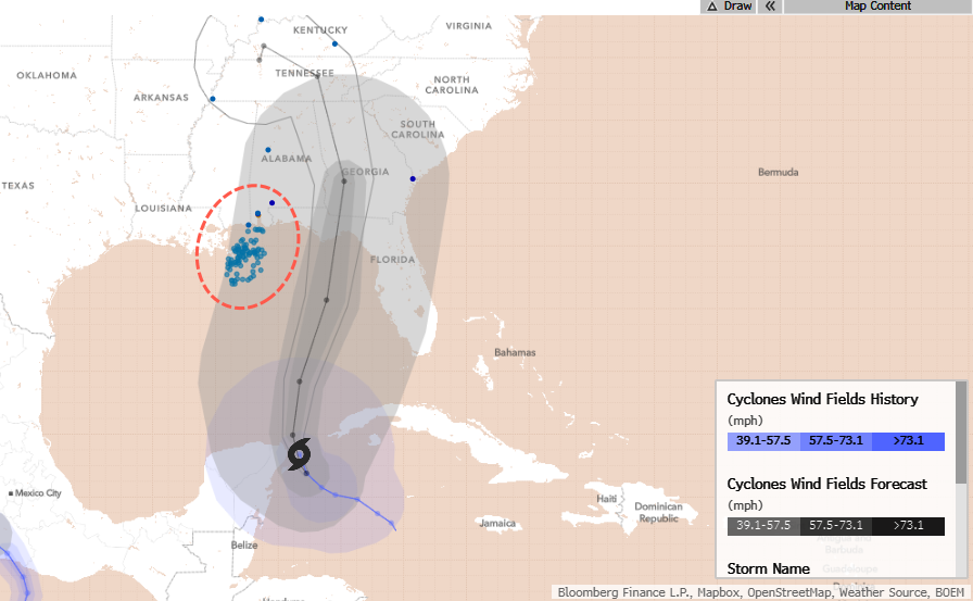
Bloomberg data shows Helene will track just right of major oil/gas infrastructure in the Gulf and onshore.
After landfall, the storm could track into the southern Appalachian area, unleashing extreme winds and torrential rains.
As many have noted, #Helene wind+rain impacts will be extreme into the southern Appalachians.
— World Climate Service (@WorldClimateSvc)
Model 850mb winds look potentially comparable to Opal, Irma, and Zeta (historically damaging N Georgia storms).
Current drought in the region will reduce impacts just a bit. pic.twitter.com/R5Jjx2wHvj
Some parts of the Appalachians are in desperate need of rain.
Here's our reporting on the storm:
-
Gov. DeSantis Declares State Of Emergency Ahead Of Dangerous Hurricane Threat
-
Tropic Trouble Brewing In Gulf Of Mexico Could "Slingshot" Towards Offshore Oil Rigs
-
"Something Brewing In Gulf Of Mexico" As Confidence Grows In Cyclone Formation Next Week
*Developing...
Свежие комментарии