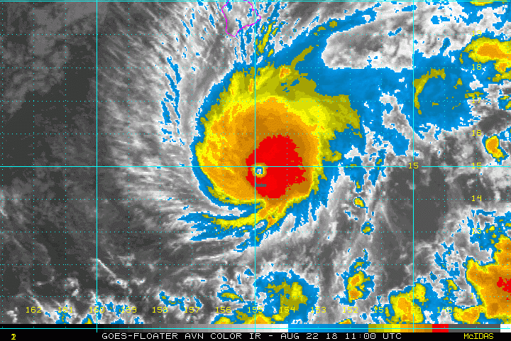
A hurricane warning has been declared for Hawaii and Maui Counties as powerful Hurricane Lane continues moving west-northwestward towards the main Hawaiian islands as a Category 4 storm.
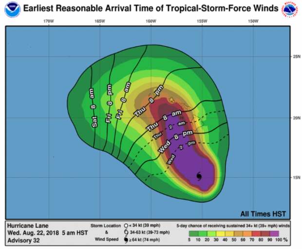
The Central Pacific Hurricane Center issued the warning early Wednesday (500 AM HST Wed. Aug 22), which means hurricane conditions are expected within 36 hours.
A hurricane watch is still in effect for Honolulu and Kauai counties with deteriorating conditions expected within 48 hours.Early Wednesday, Lane weakened somewhat from Category 5, becoming a Category 4 storm and has maximum sustained winds near 155 mph. Forecasters say there is the possibility of the hurricane making a direct hit on one or more of the islands late this week and into this weekend.
“Lane was centered 315 miles south of Kailua-Kona, and moving west-northwest at 9 mph. Forecasters say hurricane-force winds will extend 40 miles from the center, while tropical-storm-force winds can be felt 140 miles from the eye,” said Hawaii Public Radio.
Local officials are hoping the storm tracks farther west because it would lessen the severity of impacts. The strength of the storm will depend on the storm’s track in the next 12 to 24 hours.
Hawaii Gov. David Ige signed an emergency proclamation in advance of the hurricane. Schools have been shut down as the islands prepare the possibility of a direct hit.
RT @Hawaii_EMA State EOC is now activated and ready to support the counties. State and federal emergency managers on-deck. #hurricanelane #preparedness #2weekssupply #HIGov #HINews #Lane pic. twitter.com/5tj4kFSzK4
— Governor David Ige (@GovHawaii)
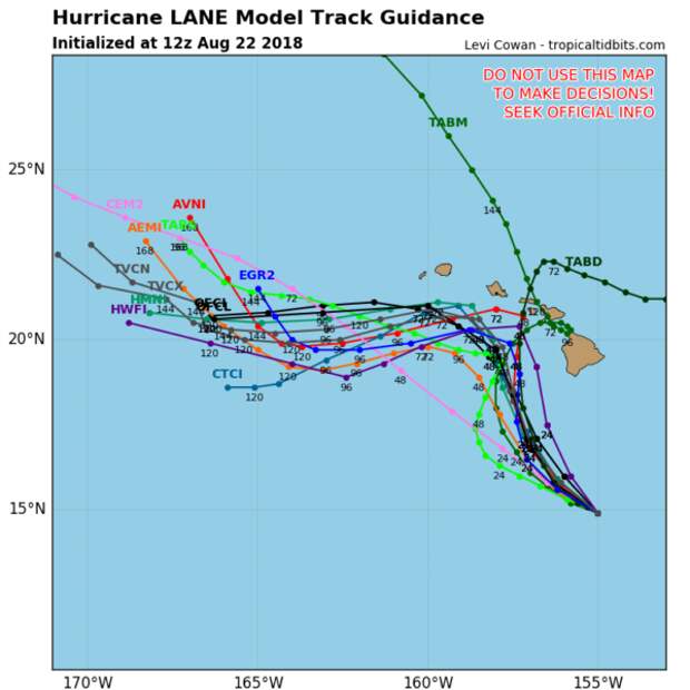
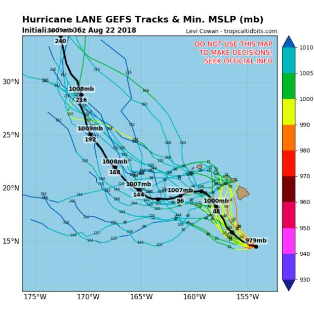
According to the latest forecast model from NOAALane will remain very strong, and dangerous.
“Lane started to turn to the west-northwest on last night. Forecasters expect it to turn northwest and then to the north-northwest tomorrow, bringing it “dangerously close” to the island chain. Weather officials say Lane can bring 10 – 15 inches of rain in some spots, but may be higher in other areas. Rain of this magnitude raises the risk of flash flooding and landslides,” said Hawaii Public Radio.
Amid the threats of a direct hit, “Lane has the potential of bringing the state of Hawaii serious and perhaps record damage,” according to AccuWeather Hurricane Expert Dan Kottlowski.
“All residents and interests on the islands should closely monitor Hurricane Lane and pay particular attention to local officials on possible evacuations and preparations,” Kottlowski said.
Global + Hurricane Models
More hurricane models
Despite some forecasts weakening and predicting a curved path away from the islands (as shown above), the storm still has the potential to bring dangerous conditions across much of Hawaii.
“Satellite-derived wind data suggests shear is starting to increase over the hurricane, and this should cause the hurricane to begin the expected weakening trend on Wednesday,” Kottlowski said. As Accuweather explained, wind shear is the increase in wind speed at increasing elevation or sudden increase in straight-line winds over distance in the atmosphere.
“However, this weakening is expected to be slow at first, and Lane will remain a very powerful and very dangerous hurricane as it approaches the Hawaiian Islands.”
According to Accuweather, Lane was a Category 5 (160-mph sustained wind) on Tuesday night and was downgraded early Wednesday.
The last time a Category 4 hurricane hit Hawaii was over two decades ago when Hurricane Kauai caused over $1 billion in damage and six deaths.
A clip of the NOAA flying their Lockheed WP-3D Orion N42RF through Hurricane lane
Scientists from @HRD_AOML_NOAA captured the eye of cat 5 #HurricaneLane as seen from the NOAA P-3 in the Central Pacific as CPHC upgraded storm's intensity. Please monitor https://t.co/GSZibx8iEh and https://t.co/l10gLxMl3r for updates as Lane approaches the Aloha State. pic.twitter.com/nkVCOhgy5C
— NOAA AOML (@NOAA_AOML)
Footage from within the eye of the storm
Video of #NOAA42 entering the eye #HurricaneLane during the 4PM HST mission. The storm was near its peak intensity, a Category 5, at this point. Taken by L. Bucci. pic.twitter.com/TTTzM23xwy
— HRD/AOML/NOAA (@HRD_AOML_NOAA)
Jeff from FEMA tells citizens to prepare for “the dangerous storm” by downloading the FEMA App on your smartphone
(8/21) If you’re in the path of #HurricaneLane, get ready now and make sure your family and neighbors do as well. Check @NWSHonolulu for the latest forecast and https://t.co/YbTCtJCzgd for more tips. pic.twitter.com/cqrZ8iFANM
— FEMA (@fema)
Safeway ran out of water
All the regular water in this Safeway is out pending possible impact from #HurricaneLane Let’s get it boyyyysss pic.twitter.com/P1a5PdZIKf
— Bradley Eversley 🇺🇸 (@ForeverEversley)
Store shelves are empty
Brada Z back at it with da Costco updates #HurricaneLane pic.twitter.com/0tjBVm38sn
— Kaiku Kaholoaa (@kaiku808)
very empty
Empty shelves @ the Foodland in Wailuku by our house #hurricanelane pic.twitter.com/0CgIRLfjXQ
— Jennifer Polito (@PRJenPolito)
***
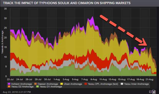
At the same time elsewhere in the Pacific, Typhoons Soulik and Cimaron are both on a crash course with highly populated and large economic zones of Southeast Asia, including Southwest Japan and the Korean Peninsula.
The storms will hit one after the other, possibly pounding two massive Asian economies on the same day. It is likely that impact of global trade in the region (as shown below) will be affected for the days to come.

